This newsletter contains important information from the North Carolina Department of Agriculture Veterinary Division in regards to Hurricane Florence. Please share this newsletter with others as appropriate. To subscribe to this newsletter, please send an email to the Veterinary Division's general email account, Joe.Web@ncagr.gov.
Emergency Management Weather Tracking
We are sending Hurricane Florence storm tracking information from emergency management twice daily. Below is the latest Hurricane Florence update.
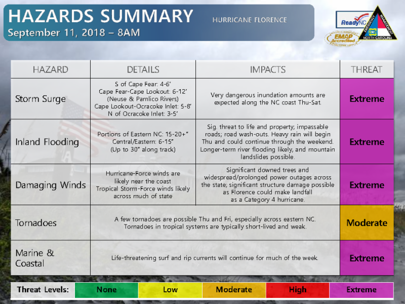
Hurricane Florence continues on its track towards the coast of North Carolina. It is expected to make landfall as a Category 4 storm with 130-156 mph sustained wind gusts. Effects from the storm will most likely begin Wednesday with the storm making landfall sometime late Thursday or early Friday. It is predicted that the storm will begin weakening shortly after making landfall and "stall out" somewhere over the eastern half of North Carolina through Sunday evening.
The Coastal Plains area could see 10-15 inches of rain. Hatteras is expected to see almost 30 inches of rain. Long-term river flooding is a real possibility. Please stay tuned to your local forecasts and use these links for important storm information.